 Valley of Fire Tours
Valley of Fire Hikes: Every Trail, Distance and Difficulty
Thirteen named trails run through Valley of Fire State Park and nine of them close for four and a half months every year. That is the first thing to know about Valley of Fire hikes, because it decides whether your visit includes the striped sandstone everybody photographs or a mile of flat wash and a viewpoint. Below is every trail with its real distance, elevation and difficulty, and what a July visitor is left with.
Quick answer
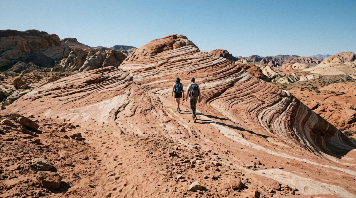
The best hike in the park is Fire Wave, 1.5 miles round trip with 236 feet of climb, and it is closed from May 15 to September 30. Outside that window, pair it with the White Domes loop at 1.1 miles for the strongest half day of walking here. Year-round, Mouse's Tank at 0.75 miles and Rainbow Vista at 1 mile are the two that never shut.
Key takeaways
- Nine trails close from May 15 to September 30 after repeated heat rescues; the closure calendar explains what is left
- Fire Wave, 1.5 miles and 236 feet of climb, is the trail people drive an hour for
- White Domes packs a slot canyon and 1965 film-set ruins into a 1.1-mile loop with 177 feet of climb
- Nothing here is long: only Prospect Trail at 11 miles and Arrowhead at 6.8 miles pass five miles. See every guided Valley of Fire tour
- A guided hike costs $129, caps the group at 12 and lets you pick easy, moderate or difficult
Every Trail at a Glance
Distance, elevation and season in one table
Distances are round trip unless noted. The last column is the one that catches visitors out, because operator listings and older guides still name closed trails as stops.
| Trail | Distance | Elevation | Difficulty | Closed May 15 to September 30 |
|---|---|---|---|---|
| Fire Wave | 1.5 miles | 236 feet | Moderate, soft sand | Yes |
| Fire Wave and Seven Wonders Loop | 1.8 miles | Rolling | Moderate | Yes |
| Pastel (Pink) Canyon | 0.4 miles from the road | Flat | Easy | Yes |
| White Domes Loop | 1.1 miles | 177 feet | Easy, one slot canyon | Yes |
| Mouse's Tank | 0.75 miles | Flat | Easy, deep sand | No |
| Rainbow Vista | 1 mile | Slight incline | Easy | No |
| Elephant Rock Loop | 0.3 miles | 52 feet | Easy | No |
| Balanced Rock | 0.4 miles | Flat | Easy | No |
| Natural Arch Trail | 2.5 miles | Rolling | Moderate | Yes |
| Charlie's Spring | 2.5 miles each way | Flat wash | Moderate | Yes |
| Pinnacles Loop | 4.8 miles | Some gain | Moderate | Yes |
| Arrowhead Trail | 6.8 miles point to point | Gradual | Easy grade, long | Yes |
| Prospect Trail | 11 miles | Rolling | Hard, cairn-marked only | Yes |
What the numbers do not show
Nothing on that list is technically hard. What makes trails here punishing is surface and exposure: deep sand that steals a third of your effort, bare rock that reflects sun back at you, and almost no shade anywhere except inside Mouse's Tank in the morning.
A 1.5-mile walk on this ground in April feels like a 1.5-mile walk. The same walk in June is the reason the park closes trails at all.
Which Trail, Given What You Have
If You have one hour and want the signature photograph
Fire Wave, from lot P3 on White Domes Road. Only between October and mid-May; the trail is shut the rest of the year
If You have one hour and it is July
Mouse's Tank at first light. It is the only walk left with anything to look at, and the wash holds shade until mid-morning
If You are walking with children
Elephant Rock at 0.3 miles, then Mouse's Tank as a petroglyph hunt. Both are flat and short enough to survive a bad mood
If You want a half day of proper walking
White Domes loop first, Fire Wave second, Pink Canyon if your legs hold. About 3.5 miles total with the driving between them
If You want to see nobody
Pinnacles Loop at 4.8 miles or Charlie's Spring at 2.5 miles each way. Carry more water than you think and tell someone your plan
If You would rather not navigate any of it
Take the guided hike, which picks the route for your level and carries the water
The Short Trails Everyone Does
Fire Wave, 1.5 miles
The reason most people come. A sheet of sandstone banded in red, cream and pink, sloping into a bowl you walk down into. The trail leaves lot P3 on White Domes Road, drops through sand, crosses open rock marked by posts, and climbs 236 feet in total across the round trip.
Go in the last two hours of daylight if you can. Low sun raises the contrast between the bands; midday flattens them into grey. The car park is small and fills first on weekends between October and April.
White Domes Loop, 1.1 miles
The most varied short walk in the park: pale domes, a slot canyon narrow enough to touch both walls, and the sandstone remains of a film set built in 1965 for The Professionals. Total climb is 177 feet, with a steep sandy descent at the start if you walk it clockwise.
Clockwise is the right direction. It puts the slot canyon early, before the sand has drained you, and leaves the open stretch for the return.
Mouse's Tank, 0.75 miles
Flat, sandy, and the best archaeology in the park. The wash runs between walls carrying Ancestral Puebloan petroglyphs, none of them signposted, so you spot them by scanning dark desert varnish as you walk. Most people miss half of them on the way in and find them on the way back.
The tank at the end is a natural rock basin that holds water for months after rain. Open all year, which makes it the default summer walk.
Rainbow Vista, 1.0 mile
A flat 1.0 mile round trip out and back to a wide overlook, with a slight incline at the start. The trail itself is unremarkable; the view at the end separates into bands of red, white and pink when the sun is low, and looks washed out when it is not.
It stays open through summer, and it is where the afternoon tour finishes for exactly this reason.
Elephant Rock and Balanced Rock
Two walks under half a mile each. Elephant Rock is a 0.3-mile loop with 52 feet of climb from the east entrance car park, ending under an arch shaped like a trunk and head. Balanced Rock is a 0.4-mile stroll from the visitor centre to a boulder perched on a narrow pedestal.
Neither needs planning and both stay open all year. Watch unfenced drop-offs above Elephant Rock, which is where the photograph everyone wants is taken from.
The Long Trails Almost Nobody Walks
Pinnacles Loop and Natural Arch
Pinnacles Loop runs 4.8 miles past arches, hoodoos and eroded spires, and it is the longest trail here that still feels like a day hike rather than an expedition. Natural Arch Trail is 2.5 miles out and back, and despite the name there is no single grand arch at the end, but several arches and alcoves along the way.
Both are closed from May 15 to September 30, and neither appears on any guided tour itinerary.
Charlie's Spring and Arrowhead
Charlie's Spring follows a desert wash 2.5 miles each way to a permanent water source with cattails and a few California fan palms, which in this landscape reads as surreal. Arrowhead Trail is 6.8 miles point to point on the line of the old Arrowhead auto road, open to hikers, bikes and horses, with a gentle grade throughout.
A point-to-point trail needs two cars or a long walk back. Plan the logistics before you park.
Prospect Trail, 11 miles
The park's serious walk: 11 miles out and back through washes and old mining roads, marked by occasional poles and cairns rather than signs. Route-finding matters, the surface alternates between sand and rock scramble, and there is no water anywhere on it.
This is a cool-season, early-start, tell-someone-where-you-are trail. It closes with everything else on May 15.
What Summer Leaves You
Two and a half miles in 40,000 acres
From May 15 through September 30, Nevada State Parks closes White Domes Loop, Fire Wave, the Seven Wonders Loop, Pastel and Pink Canyon, Pinnacles Loop, Prospect Trail, Arrowhead Trail, Natural Arch Trail and Charlie's Spring. The park's stated reason is a history of frequent medical calls, search and rescue missions and fatalities in that window.
Every Valley of Fire tour from Las Vegas runs through the closure regardless, on the roadside stops. What remains open on foot comes to about 2.5 miles of trail: Mouse's Tank, Rainbow Vista, Elephant Rock, Balanced Rock and the roadside stops. Rangers enforce the closures and issue citations.
Why the closure is not an overreaction
Average highs run 100°F in June, 105°F in July and 103°F in August, and those are shade readings taken at instrument height. Bare sandstone in direct sun runs far hotter, which is what turns a 1.5-mile walk into a rescue.
The practical consequence for a visitor is simple. If Fire Wave is the reason you are going, book between October and mid-May. Our month-by-month guide sets out the trade-offs for each window.
Heat, Sand and the Rules That Keep You Out of Trouble
Water, footwear, timing
There is no water on any trail here and no shop inside the park. The visitor centre sells water between 9 a.m. and 4 p.m. and is the only refill point.
- Carry at least 1.5 litres per person for anything over a mile, double that from May onward
- Closed-toe shoes with grip; sand fills sandals and polished sandstone is slick underfoot
- Start before 9 a.m. or after 3 p.m. in any month with a high above 90°F
- Hat, sunglasses and sunscreen; the pale rock reflects as much sun as the sky delivers
- Download the trail offline before you leave the freeway, because signal fails on Mouse's Tank Road
- Tell someone your route if you are walking anything past Rainbow Vista
The sand nobody warns you about
Half the walking here is on loose sand that gives with every step. It roughly doubles the effort of a flat mile and it is why visitors describe short trails as harder than the distance suggests.
The other surprise is navigation. Several trails cross bare rock where the path exists only as posts or cairns. In good light this is obvious; at dusk it is not, which is a good reason to be walking back before the sun is on the horizon rather than after.
Water and timing by season
How much to carry and when to start, by the month you are walking in.
| Month | Typical high | Water per person for 1.5 miles | Start by |
|---|---|---|---|
| December to February | 57°F to 63°F | 1 litre | Any time; sunset is before 5 p.m. |
| March and April | 72°F to 79°F | 1.5 litres | 9 a.m. to beat the car parks |
| May | 89°F | 2 litres | 7 a.m.; closures begin May 15 |
| June to August | 100°F to 105°F | 3 litres | 7 a.m., and be off the trail by 10 a.m. |
| September | 95°F | 2.5 litres | 7 a.m.; trails reopen October 1 |
| October and November | 68°F to 82°F | 1.5 litres | Any time before mid-afternoon |
Walking It With a Guide
What the guided hike does differently
One operator sells the park as a hike rather than a drive. The guided hike costs $129, runs four to six hours, caps the group at 12 and sells three difficulty levels that cover genuinely different terrain rather than the same trail at three speeds. Tips are included, which is unusual here.
The easy level covers petroglyph panels and arches on solid ground and is sold as suitable for families. The difficult level involves rock scrambling and is not sold to children under 8. Guides pick routes that avoid the busy stops, which is the real product: on this ground, twenty minutes off the road puts you alone.
When to drive yourself instead
If you want the long trails, or sunrise and sunset in the same visit, no tour will do it. Every departure from Las Vegas is built around a fixed window, and none of them reaches Prospect, Arrowhead, Charlie's Spring or Pinnacles.
For everything shorter, the eight trips are compared on our guided Valley of Fire tours page: the $99 half day and the $129 full day both walk out to Fire Wave outside the closure window.
Questions About Hiking in Valley of Fire
What is the best hike in Valley of Fire?
Fire Wave, at 1.5 miles round trip with 236 feet of climb. It ends on the striped sandstone the park is known for and takes about ninety minutes with photographs. It is closed from May 15 to September 30, and in those months White Domes would be the answer if it were open; since it is not, Mouse's Tank takes the title by default.
Why are Valley of Fire trails closed in summer?
Nevada State Parks closes nine trails from May 15 through September 30 because they have a history of frequent medical calls, search and rescue missions and fatalities in the heat. Average highs reach 105°F in July, and surface temperatures on bare sandstone run far higher.
How long does it take to hike Fire Wave?
Between 45 and 90 minutes for the 1.5-mile round trip, depending on how long you spend on the rock. The walking itself is straightforward; the sand is what slows people, and most visitors stay longer than they planned once they arrive.
Are there easy hikes in Valley of Fire?
Yes. Elephant Rock is 0.3 miles, Balanced Rock 0.4 miles, Mouse's Tank 0.75 miles and Rainbow Vista 1 mile, all flat or nearly so, and all open year-round. The White Domes loop at 1.1 miles is also easy but shuts for the summer.
Can you hike Valley of Fire with kids?
Mouse's Tank works best because the petroglyph hunt gives children a reason to keep walking. Elephant Rock and Balanced Rock are short enough for small legs. Avoid Fire Wave with under-sevens in any warm month; the sand and the exposure are more than the distance suggests.
Do you need a permit to hike here?
No permit, just the vehicle entry fee of $15 for out-of-state visitors or $10 for Nevada-registered vehicles. There is no reservation system and no trail quota; the only access restriction is the seasonal closure.
What movie was filmed in Valley of Fire?
Several, and the one you can still walk to is The Professionals, filmed in 1965, whose sandstone set ruins sit on the White Domes loop. Star Trek Generations shot its final scenes here in 1994, near the east end of the park, and Total Recall used the landscape as Mars. Only the White Domes ruins remain as a visible film location on a trail.
If you have one shot at this park and want to walk, book between October and mid-May, drive to the end of White Domes Road first, and be on Fire Wave for the last light of the day.